
The Compass: Introduction to Maps 1.4.1:
- Chris Cowdrey

- Apr 30, 2020
- 6 min read
Updated: Jan 16
If you like what you read please support me by making a small donation if you can :)
More in this Series:
Below is the answer sheet to the questions in the last part
Part 4.1 of my Introduction to Maps series takes a look at the compass, what it is and how we use it for navigation.
The Compass
The compass is a versatile tool for us navigators. Coupled with a map and it provides assistance with navigation techniques:
Measuring distance on a map
Helping to plot grid references
Taking a bearing from the map and the ground
Walking on a bearing
Orientating the map
Checking the direction of handrails
Taking an aspect of slope
These navigational techniques will be covered in a later series, but first, let's take a look at what types of compass there are.
Types of Compass

The three types of compass we are likely to use in the hills and mountains are as follows:
Base Plate
Sighting
Electronic
Base Plate Compass
This is the most common compass we use in the hills and mountains and the one I will focus on in this article. They are lightweight and robust. The two main parts to a base plate compass are the magnetic needle housing and a transparent base plate.
Sighting Compass

They usually come as either mirrored or prismatic. They are good for sighting a bearing on a distant object and walking on a bearing, however, due to their small base, they lack the versatility of a base plate compass when it comes to taking bearings from the map, measuring distances and grid references.
Electronic Compass

These types of compass are usually incorporated into watches and GPS devices but it is possible to buy a dedicated electronic type compass. They are useful for checking direction, however that is about as far as their use goes. Without having a base plate, you are unable to take bearings from a map with them. As with all technology, they must not be relied upon due to batteries running out and damaging them. With this in mind, it is always a good idea to carry a backup, non-electronic compass
Parts of a Compass

The above image is from the book 'Navigation in the Mountains' and shows a compass with it's main parts labelled. We will go into more detail below:
Orienting arrow and Orienting lines:
These are situated in the rotating compass housing and are used to take a bearing. The orienting lines are parallel lines either side of the orienting arrow.
Compass Needle:
This is the magnetic needle that freely rotates within the compass housing. One end of the needle is coloured, usually red, and it is this point that points to magnetic north.
Bearing Numbers:
Around the edge of the compass housing are numbers. These are used to give a bearing reading. They will either be in degrees or mils:
Degrees: There are 360 degrees going up in 2 degree increments.
Mils: There are 6400 mills going up in 50 mil increments. Used by the military for artillery and more accurate than degrees, however we, as civilian navigators, will never need that level of accuracy, but mils can still be used for bearings.
Romer Scales:
We have covered these in Parts 3 and 4 of my Introduction to Maps series. They are used to measure distance and grid references. The common romer scales found on a compass are:
1:25,000
1:40,000
1:50,000
1:63,360 (this scale is found on older compasses and is no longer of use)
Direction of Travel Arrow:
This arrow is used to point you in the direction of your bearing or to an object in the distance.
Magnifying Glass:
This is used to look at the detail of a map, for example small contour features that may be behind other symbols.
Compass housing:
This is a rotating bevel that houses the magnetic needle and has the bearing numbers along it's edge. It is usually filled with an oily substance to help dampen any vibrations to settle the magnetic needle quicker, giving more accuracy.
Base Plate:
Base plate compasses come in many sizes but the most versatile is a 10cm long base plate. It is transparent to be able to view map detail underneath, has the romers printed onto it, along with a millimetre ruler for measuring distances and thin black lines to help with taking a bearing.
Other features:
Most base plate compasses also come with the following features to aid in navigation:
'Glow in the dark' strips: These will help navigating at night. They are usually situated on the north needle, direction of travel arrow and either side of the orienting arrow.
Rubber 'feet': These help stabalise the compass on a map case when taking a bearing
Lanyard: Used to attach the compass to a zip or map case to prevent you from dropping the compass
Using a compass and considerations
A compass works by relying on the magnetic needle. When taking a bearing and relying on the compass to navigate, metallic objects can interfere with the magnetic needle and give you false readings.
When using a compass ensure you do not hold it too close to the following:
Metal zips on your jacket
Metal water bottles
Mobile phones, cameras or any electrical device.
Magnetic clips used on some water bladders to attach the hose to a rucksack strap
Walking poles
Other considerations when using a compass is to be aware of the environment around you. Metal gates and fences and vehicles can all alter a compass needle giving false readings. And certain types of rock are know for their magnetism, such as gabbro, found on the Isle of Skye.
Be aware of how and where you store your compass too. Don't store your compass in the same pocket as your mobile phone, for example, as prolonged exposure to another magnet can depolarise your compass. This means, the north arrow will no longer point north but instead, reverse polarity and point south.
At home, after you have bought a new compass, stand in the middle of a room or your garden, away from any other magnets, metal and electronics and see where North is. Use this as a reference point every time you get your compass out to take out with you. That way you can ensure your compass still points north and hasn't reversed polarity.
The Three Norths
How many Norths? In navigation, we refer to three Norths:
True North: The geographic North where the Earth spins on it's axis
Magnetic North: A point where Earth's magnetic field lines are perpendicular to the surface. This is what your compass needle points to.
Grid North: This is what the vertical grid lines (Eastings) on a map point to. It varies ever so slightly to true north.
The difference between magnetic north and grid north is known as magnetic variation.
Magnetic Variation
Magnetic North is constantly moving eastwards. Information of it's movement is printed on all OS and Harvey Maps. This is important as slight inaccuracies in bearings can create errors on the ground. See the example image below.

The above image is an exaggeration but entirely possible if magnetic variation hasn't been taken into account.
As it stands in 2020, the magnetic variation in the UK is minimal but changes from the East of the UK to the West. It is still important to work out the variation and adjust your bearing accordingly.
Working out Magnetic Variation

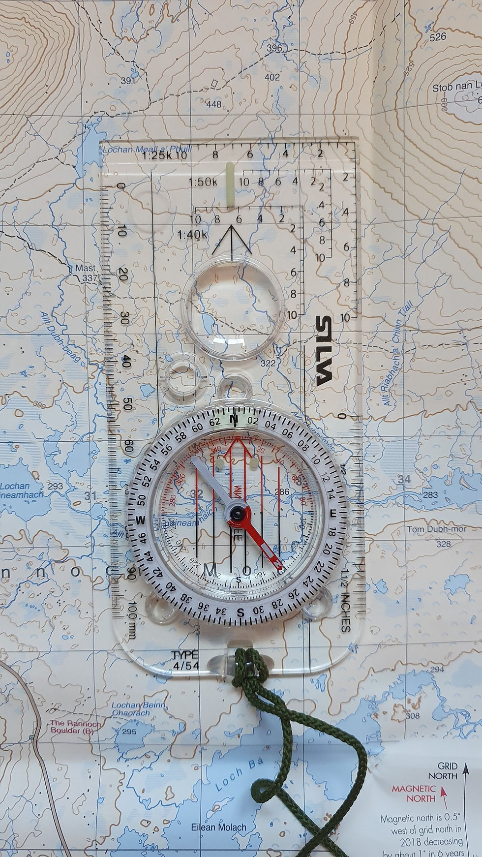
Take a look at the above image. It states:
Magnetic north is 0.5 degrees west of grid north in 2018 decreasing by about 1 degree in 6 years
This means the difference in 2018 between grid and magnetic north is half a degree. In 2021, the difference will be 0. However, in 2024, magnetic north will be 0.5 degrees EAST of grid north.
The two images below give more examples but come to the same conclusion.


Knowing the magnetic variation, we can add or subtract the variation to our bearing to give us an accurate bearing and minimise errors.
Grid bearings are taken from the map
Magnetic bearings are taken off an object on the ground, in the distance.
With the above in mind:
From a grid bearing to magnetic bearing you ADD the magnetic variation.
From magnetic to grid bearing you SUBTRACT the magnetic variation
A popular rhyme to remember this is:
Grid to Mag ADD, Mag to Grid GET RID
One point to note here though: In the next few years, magnetic north will cross grid north from the EAST into the WEST. When this is the case, the above rhyme will not be of use as it will be reversed.
But for now, ensure you know the magnetic variation of the map and the area you are in and adjust your bearing accordingly.
(We will cover how to take a bearing in a later article)
This brings us to a close of my Introduction to Maps series.
If you have been following this series, I hope you have found it useful and informative and inspired you to learn more!
If you like what you read please support me by making a small donation if you can :)
To put these skills into practice and to learn more, take a look at my Navigation Courses I offer.
All confirmed bookings will receive a 10% discount code to use on Harvey Maps products from their site.
Next Up:
My next series in navigation will be NAVIGATION TECHNIQUES
See you At The Edge!


Comments