
Symbols & Features: Introduction to maps 1.2:
- Chris Cowdrey
- May 3, 2020
- 5 min read
Updated: Dec 30, 2025


If you like what you read please support me by making a small donation if you can :)
Join the Community!
I have created a community for people reading through, or who have completed, my Online Navigation Course.
It supports those learning navigation theory remotely and looking to deepen understanding through discussion, reflection, and shared experience alongside others on the same journey.
More in this series:
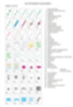
Below is the answer sheet to the questions in the last part:
Map Symbols and Features
Part 2 in my Introduction to Maps will look at map features and symbols, what they are and how to use them.
As mentioned in my last article, a map is a two-dimensional, or birds eye view of an area. To visualise the main features on the ground, symbols are used to help us understand what is around us. From the shape of the land and type of terrain, to railway stations and even phone boxes (remember them?), symbols show, in great detail, all the information we need as navigators.
There are hundreds of symbols and abbreviations used on maps, and the symbols used by OS are not the same as those used by Harvey Maps, so as to not overwhelm you, I have condensed this article down to the main points:
What are symbols
How do we use them?
To learn more about navigation, book onto one of my navigation courses.
Map Legends
Open up a map for the first time and the lines and symbols will not make much sense at first. What are those blue lines? What is that triangle with a dot in the middle? And what are those dashed lines?
The answer to these questions can be found in what is known as the Map Legend or margin of information. This is a list of all the signs and symbols found on the map and a good starting point to learning how to read a map.
On OS maps, the legend is usually found at the side, in a corner or the top of the map.
On Harvey Maps it is either on the reverse of the map or in a corner.


Above images:
Left: OS maps showing the legend at the top of a map and at the side
Right: Harvey map showing the legend in the corner
The legend will also give you more information about the map, such as the year it was printed, the north points and magnetic declination (more on this in a later article), the map area, scale and sheet number.
Learning the Legend
At first glance, it may seem like an endless task to try and learn all the symbols in a map legend. So to begin with, I will break the legend down into three types of features to try and help you learn some of the key symbols as a starter. These features are:
Linear Features
Spot Features
Area Features
For your own reference, I have highlighted below where you can download the legend for both OS maps and Harvey Maps so you can learn symbols for yourself.
Download OS map legends:
Download Harvey Map legends:
Linear Features
Linear features are 'lines' on the map that you can use to follow. They are commonly referred to as 'handrails' (much like a banister on the stairs is used to 'lead' you up them as something to 'hold on to').
Examples of linear features (or Handrails) are:
Rivers and streams
Roads and tracks
Footpaths and other public rights of way
Boundaries
Major landforms such as ridge lines
Example of OS Linear features


Example of Harvey Maps Linear features


At a basic level, we use handrails to orientate the map to the ground and relating the features on the map to those on the ground. I will cover this in more detail in a later article.
Spot Features
Spot features are small points or single point features that pinpoint a particular location.
Examples of spot features include:
Small lake or pond
Track junctions
Triangulation Pillar (Trig Point)
Footbridge
Buildings
Area Features
Area features are large features. Examples include:
Lakes
Woodland and forests
Marshes
Slopes
I have purposely not added examples above for Spot and Area features as I want to encourage you to look at the Legends of maps and find them for yourself. Below is an image from a Mountain Training Publication (Hillwalking) which shows examples of all three types of features. Have a guess at what types of feature are numbered. Answers at the end of this article.

To learn more about OS map symbols, take a look at their Flash Cards
Once you are able to identify a few symbols for each type of feature, you can begin to develop the basic skills to navigate along footpaths. These symbols and features are the key to learning navigational techniques to aid you following a route. Two of these techniques are 'Collecting' and 'Catching' features.
Collecting Features
This is a technique used to help keep you on track and know where you are. It involves looking at your route on the map and identifying symbols along your route that you will pass by. As you pass by these features on your walk, you 'collect' or 'tick off' these features. This helps you visualise your walk and enables you to stay on track as you know what features to look out for.
Catching Features
These are effectively a 'back stop' (like in cricket) or a safety net to 'catch' you if you have gone too far. Take a look at your route and look beyond your objective to find a large obvious feature that isn't too far away (a few hundred metres). This could be a large area feature (such as a woodland or even change in direction of the slope) or maybe a linear feature such as a stream or a footpath. As the saying goes; "If you get to this feature, you've gone too far"
I will go into more detail about Collecting and Catching features in a later article.
Finally, take a look at this extract below from Harvey Maps Superwalker XT25 - Snowdonia North. Use the Downloadable Harvey Maps legend and see how many features and symbols you can find in this area.

Below is the question sheet to this article.
Answers to these questions are in the next Part of this series.
Next Up:
The next article in this series will be Part 3: The Grid system and Grid references
Stay tuned for updates by signing up to my newsletter!
If you like what you read please support me by making a small donation if you can :)
To learn more, take a look at my navigation courses and National Navigation Award Scheme courses. All confirmed bookings will receive a 10% discount code to use on Harvey Maps products from their site.
See you At The Edge!
Answers to 'what types of feature' image:
Spot
Spot
Spot
Linear
Linear
Linear
Area
Area
Area