
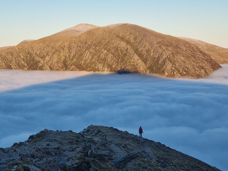
This mountain navigation course in Snowdonia, the Brecon Beacons or the Lake District is designed to allow you to progress into more remote areas of the British mountains and navigate the complex, steep terrain of the UK mountains. You will learn how to navigate using the shape of the ground, how to recognise and avoid steep, dangerous terrain, and the skills to relocate yourself in all visibility.
By the end of this course, you will have gained the confidence and ability to undertake bigger mountain walks in more complex and remote terrain.
Instructor Tip:
"Move to prove! Look ahead on your map, what do you expect to see? When you set off, you'll have an idea of what to expect the ground to do, or features you'll see. If on your journey the ground doesn't do what you expected, or you have not yet seen the features, STOP and replan. Move around your location (if safe to do so!) and get a better/different vantage point ('Travel to unravel'). Return back to your original position with your new found information and make a plan!"
£80pp*
1 Day
1:6
* Price indicated is for public course dates. For private/bespoke/1:1 bookings, prices start FROM £220 per day, +£30 per person extra. Get in touch to enquire or click the BESPOKE BOOKING button above.
COURSE OVERVIEW:
This course is for experienced hill walkers who want to start to explore the bigger, more remote mountain walks in the UK, and to gain the knowledge and experience to safely venture into more complex terrain. This course is more focused on navigating in the complex terrain of the UK mountains on a quality mountain day. It is journey based, meaning we will embark on a classic mountain route and navigate our way around it. Mountain navigation will focus on using major features to help us navigate, as well as looking at how to avoid steep, dangerous terrain and develop skills to assess the terrain and know when to turn back or change your route.
WHO'S IT FOR?
-
Those of you who have experience in navigating in the hills and easier mountains of the UK
-
You may have done my INTRO TO NAVIGATION, INTERMEDIATE NAVIGATION and/or ADVANCED NAVIGATION courses
-
You are possibly considering going for the Hill and Moorland or Mountain Leader qualifications
-
An individual who wants to tick those more difficult and remote Wainwright Summits, Munros or classic Grade 1 scrambles!
-
Experienced hill walker who wants to develop their navigation skills, possibly taking friends and family out on walks and wants the confidence to navigate safely in all conditions
-
A fit individual, capable of walking up and down steep, uneven and featureless terrain, all day for 6+ hours / 10+km
This course is more focused on navigating in the complex terrain of the UK mountains on a quality mountain day. The course is journey based, meaning we will embark on a classic mountain route and navigate our way around it. Mountain navigation will focus on using major features to help us navigate, as well as looking at how to avoid steep, dangerous terrain and develop skills to assess the terrain and know when to turn back or change your route.
DIFFICULTY:
(7/10) Challenging - Hard
A full mountain day with significant ascent and real mountain terrain.
Similar difficulty to: Intro to Scrambling
Harder Than: Advanced Navigation
Not sure what this means? See our Difficulty Guide → HERE
Compare other Hill & Mountain Walking Courses
COURSE CONTENT:
We will cover most, if not all of the following skills on this course:
-
Use of altimetres
-
Accurate compass work
-
Poor visibility navigation techniques
-
Map memory
-
Contour only navigation
-
Small contour features
-
Micro navigation
-
Aspect of slope
-
Back bearings
-
Relocation strategies
-
Map memory
-
Dead reckoning
-
Using the group to aid navigation
-
Escape routes and emergency procedures
WHAT TO EXPECT:
-
A full day in the mountains with hands on navigation practice
-
A quality mountain day
-
Progressive learning in navigation techniques
-
Safe, friendly atmosphere with others passionate in the outdoors
-
A focus on your safety
-
Opportunities to practice hands on navigation under the watchful eye of an experienced instructor
-
Low ratio group numbers to focus on your personalised instruction


Mountain Navigation Course Dates
Want some pre-course learning?
Check out my blog post from my online navigation course below on Navigation Strategiesfor some prior learning before attending the course and see if it is right for you!


WHAT'S NEXT?
DEVELOP:
-
Guided Mountain Walks
-
Scrambling Courses (Snowdonia/The Lake District ONLY)
PROGRESS:
-
Please refer to my FAQ page for more general information and visit my DOWNLOADS page for kit lists and booking forms.
